 Finding and catching fish just became easier for C-MAP Genesis Edge customers. Bottom-hardness map layers are available now — via download from Social Map — for all premium Genesis subscribers, without additional cost.
Following the release of C-MAP’s new Social Map bottom-hardness layer, Genesis Edge subscribers will no longer have to survey a waterbody entirely by themselves in order to get a bottom-hardness map with 1-foot-contours. Bottom-hardness layers for thousands of highly detailed, community-sourced contour charts are now available to Genesis Edge customers with no more effort than the click of a button.
Why is knowing bottom hardness important?
They say 90% of the fish are in 10% of any waterbody, quite often around rocky areas, where they hold, feed and breed. So if you want to increase your chances of catching more and bigger fish, knowing where to find them is key. 1-foot contours are a step in the right direction, but bottom hardness data points to the most-productive spot-on-the-spot areas.
 What will you be able to see?
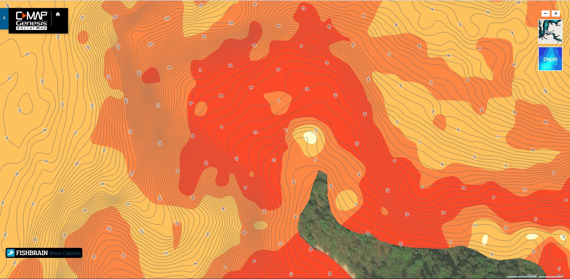
A bottom-hardness map layer, overlaid atop a C-MAP Genesis-created 1-foot-contour chart, helps anglers more easily and quickly locate fish-holding rock, gravel, sand, clay and shellbeds. Dark orange areas show the hardest bottom; a lighter orange indicates the next-hardest bottom; tan is the next-hardest bottom; and pale yellow shows the softest-bottom areas. Your contour lines will be visible through the bottom-hardness layer, so it will be easy to see at what depth the transition areas are located
How do you get the Social Bottom Composition Layer?
Easy! Subscribe to C-MAP Genesis EDGE for $99 a year or $24.99 a month.
Additional Genesis Edge subscription features include:
– Submerged-vegetation layer for custom maps
– Sonar re-play
– Minute-to-minute weather information archived in sonar data
– Option to keep private any areas personally mapped
– Fishbrain catches overlayed atop online Social Map charts
Note: Upon insertion into a compatible Lowrance sonar/GPS unit, a C-MAP chart containing a bottom-hardness layer will default to showing that layer upon start-up. Steps to turn off (or later, back on) the bottom-hardness layer (it will be called “(AREA) Vegetation/Composition” in the menu) are:


Hi Greg
I have stopped using the vegetation and bottom hardness layers in the sea as they are very inaccurate (I am a diver and know that these maps do not interpret the differences between rock covered with weed and bare rock and soft sediment at all well). Is there anything I can do in the sonar settings on my Simrad Go 12 that might make the maps at least somewhat accurate?
Regards
Mark Denize
Mark,
What kind of transducer are you using?
Also, how deep are the areas you are diving?
— Greg
I bought genesis edge. I uploaded maps of a couple local lakes to gen3-12 and it is not giving bottom hardness just contours. Then I the lake I went lake wasn’t in graph and having problems loading my c- map period. HELP
Matthew — Did you drive your boat faster than 10 miles per hour while mapping? That definitely would result in getting contours, but no bottom-hardness layer. Bottom-hardness layer will only be created in file when boat speed remains under 10 mph. … Regarding, “Then I the lake I went lake wasn’t in graph and having problems loading my c- map period” — can you tell me what steps you tried in order to get your custom map loaded onto your graph? — Greg
I can not generate Maps.
I have uploaded over 80 Sonar Logs in SL2. and Slg. format and merged different numbers to try and Generate a map. When I Click generate after some time I get the following Message.
Map Options.
Target Device. Simrad Yachting NSS evo3
Include Layer. Composition and Contours
Map failed to generate. Please try again.
Please Help.
Please email genesis.support@navico.com
Hi Greg
It’s great that under the Genesis Edge license I can download bottom hardness maps. However, there is a drawback. If I download the bathymetric map and hardness map of the bottom of a given lake for one memory card or for two cards (each map on a separate card), my device (HDS Carbon) reads only one of these maps. It is not possible to select maps from the user panel.
Can this inconvenience be eliminated?
Regards
Cezary
I’m using a Genesis Edge account. Unfortunately, I can’t use bottom hardness maps and bathymetric maps of the same lake at the same time. My device (HDS-12 Carbon) only reads one of these maps. It is not possible to choose which map I want to use, regardless of whether the maps are placed on one SD card or two cards separately. Can this inconvenience be removed?
If you put each chart into a separate folder on the same SD card you can toggle between the two.
No, It’s not true. If I put each chart into a separate folder I can’t toggle between the two because device see only one map.
It will only “see” one map at a time, correct. But if you go to “Chart Options” you can toggle back and forth between the two different maps there — they will both appear in the “Chart Options” menu to choose from.
Have you tried going into “Categories” on your chart and checking Vegetation/Composition? That will turn on/off the composition display.
I have recently uploaded multiple files using WIFI on my HDS Live and they have never showed up on my Genesis account. its been two weeks.
Hello. I have a Hook2 and cannot get the bottom composition layer to display. It is checked in the chart options but all I see is the Genesis layer that has depth contours. Is the Hook2 able to display bottom composition? I tried to download the composition map on 2 different lakes but with the same result
I have 3 Lowrance HDS Live 12 units. Two at the wheel and 1 up front. The Lowrance CMaps Alabama chip loads sometimes and other times it doesn’t. Is there a setting or something that I’m missing? CMaps Alabama is a great tool when it works and much better than Navionics.
This is the second CMaps chip I have tried and both did the same. Very frustrating when it won’t load. Please help!