C-MAP and Fishbrain partner to integrate maps and app

An innovative integration of map and app enables anglers to use historical catch locations to catch more and bigger fish in the future.

C-MAP, the leading supplier of digital marine cartography and cloud-based mapping solutions, and Fishbrain, the world’s largest angler-focused app and social network, launched a partnership that will show Genesis Edge subscribers tens of thousands of public Fishbrain catch locations on C-MAP Genesis charts online and let Fishbrain Premium subscribers see waypoints and their GPS position overlaid on C-MAP Genesis maps on their phone.

Genesis Edge is a premium upgrade to the free marine-mapping service C-MAP Genesis (formerly known as Insight Genesis). Fishbrain premium, an upgrade to the free app, provides anglers additional tools and insights designed to help them catch more and bigger fish. Continue reading “C-MAP and Fishbrain partner to integrate maps and app”

How to create and use a C-MAP Genesis Edge bottom-hardness map layer to catch more and bigger fish

Many anglers “beat the bank” because they have more confidence targeting visible cover. But the fish in those areas get pounded, making them harder to catch. With a C-MAP Genesis Edge bottom-hardness map, however, you can fish the bottom as confidently as you do the bank, targeting offshore structure like hard-to-soft-bottom transitions and the fish-holding sweet spots on humps, reefs, and shoals, etc. This article will teach you how.

Although it’s a great fish-finding tool, StructureScan alone can’t really show you the size and shape of hard-bottom areas like gravel patches, clay slicks and shellbeds. But C-MAP’s Genesis Edge bottom-hardness layer makes such areas stick out like “Fish Here!” signs on your map. It overlays onto your contour lines a color-coded representation* of the size, shape and location of areas of different bottom hardness: dark orange areas show the hardest bottom; a lighter orange indicates the next-hardest bottom; tan is the next-hardest bottom; and pale yellow shows the softest-bottom areas.

Previously, bottom-hardness layers were available only for waterbodies you map yourself. But with a Genesis Edge subscription, you can now get them for hundreds of select waterbodies available for download from Social Map. Continue reading “How to create and use a C-MAP Genesis Edge bottom-hardness map layer to catch more and bigger fish”

How to create and use a Genesis Edge vegetation map to catch more and bigger fish

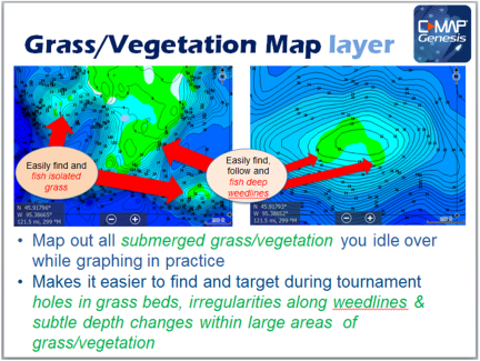
Big gamefish ambush little baitfish in both submerged vegetation and along deep weed lines, neither of which are visible to the naked eye in most weather and water conditions. But with a Genesis Edge map, you can easily find and fish both deep weed lines and isolated submerged grass. This article will teach you how.

With a Genesis Edge account (formerly Insight Genesis premium), you can create a custom grass map that will overlay on your blue-scaled contour map easy-to-see green patches that show the size and shape of the areas of submerged grass/vegetation you mapped.* Continue reading “How to create and use a Genesis Edge vegetation map to catch more and bigger fish”